
What is the Santa Clara River Loop Trail?

The Santa Clara River Loop Trail brings people to the River. Providing safe, everyday public access changes the paradigm of River perception from a flood control problem to an invaluable water resource. The SCRLT will be a recreational resource for nearby residents to learn about and gain appreciation of the River value. It is an educational resource for schools, some directly on the riverbanks and others within walking distance, to use year after year as a learning tool. It provides connectivity to thousands of people within bicycling and walking distance for alternate transportation and is a place to achieve an active healthy lifestyle.
Leadership from Friends of the Santa Clara River and Sierra Club with the assistance of the National Parks Service have undertaken a study for a SCRLT to further protect and preserve the value of the Santa Clara River. Their goal is to see the SCRLT raise environmental literacy and instill a larger movement toward stewardship of the Santa Clara River.
How did the Trail idea get started?
A wide variety of public and private efforts for protection and preservation of the Santa Clara River emerged in the 1990s. A first big accomplishment included the Santa Clara River Enhancement & Management Plan (SCREMP, May 2005), which formalized the vision of long-term river conservation and engaged otherwise conflicting stakeholders in a collaborative manner. State Coastal Conservancy (SCC) purchased River property starting in about 2000 and continued over about the next 10 years acquiring thousands of acres for the purpose of producing a Santa Clara River parkway from the ocean partially through Ventura County. Two of the major parkway goals were to preserve flood protection and provide public recreation. The Nature Conservancy served as land manager of the acquired properties and, along with SCC, invested years restoring natural habitat on selected areas of the river. Many other valuable studies for River conservation have been prepared and vary widely in authorship and topics.
The SCRLT concept draws upon these efforts and other work that is already completed and approved by other organizations. The project is favored by all stakeholders but challenges involve overcoming jurisdictional boundaries and partnering on construction, maintenance, and operations funding. A SCRLT requires greater than usual integration of parties and projects on the regional Santa Clara River conservation efforts.
Where is the Trail?
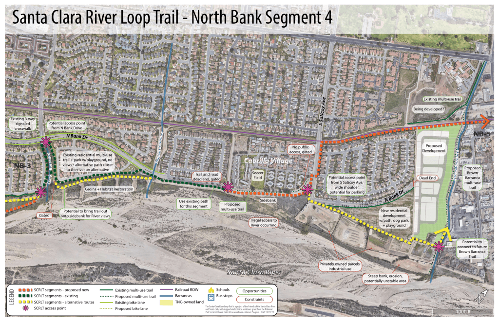
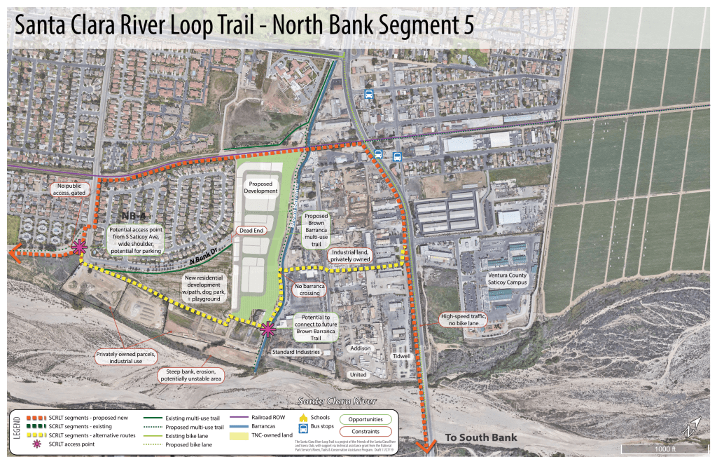
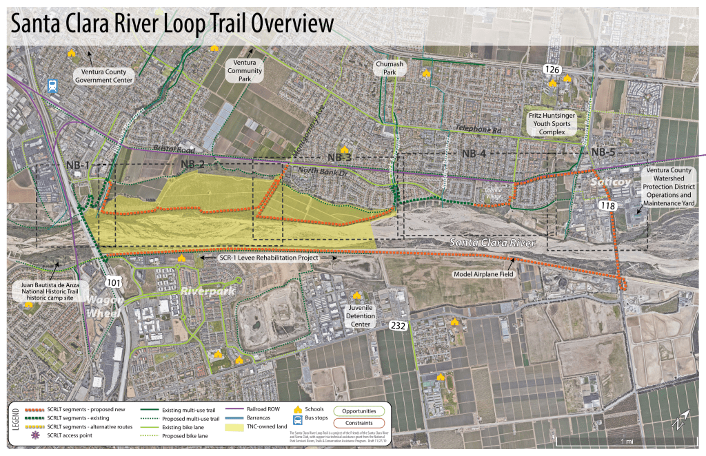
The SCRLT is proposed as a continuous route on north and south banks of the Santa Clara River between and including segments along Hwy 101 and State Route 118. The total distance of the trail is about 8.0 miles. Some segments of the trail already exist including the Hwy 101 pedestrian/bike bridge segment at the downstream end of the trail over the River and some segments in the City of Ventura. The immediate SCRLT users are in Ventura housing communities (north side), Oxnard communities (south side), as well as Saticoy (unincorporated county east end) and smaller residential unincorporated areas. Additional high-density residential areas are being constructed within the SCRLT area including the area just downstream of Hwy 101 in Oxnard (south side). A number of elementary and middle schools on both north and south banks are within walking distance of the SCRLT.
The entire SCRLT along the south bank is proposed on the top of the existing levee. The levee is compacted unreinforced earth and is the subject of a rehabilitation project known as SCR-1 (Santa Clara River Reach 1) led by the VCWPD. The levee is under the Army Corps of Engineers jurisdiction. The downstream half of the SCRLT along levee is lined with housing, schools, business, and retail development. The upstream half of the SCRLT along the levee is adjacent to low density development, as well as existing and future groundwater recharge basins, and industrial operators (cement and construction materials). A model airplane club has an airfield inside the levee along the SCRLT.
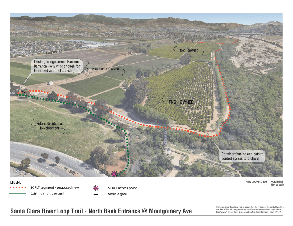
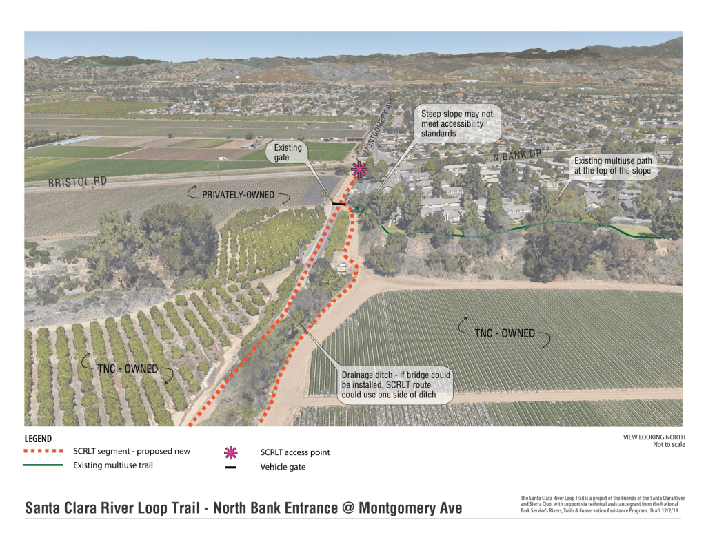
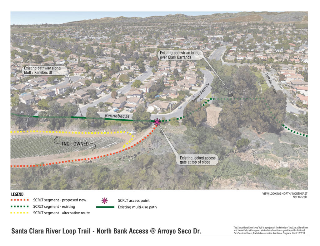
Along the River north bank the trail is located through agriculture owned but leased by The Nature Conservancy. The trail user and farm interface can be designed to be compatible for both safe riders and secure farm operation. The trail will provide full connectivity through Ventura neighborhoods, a highly desired but not yet existing factor in the area. In addition, the trail will serve Cabrillo Village and Saticoy, two low income disadvantaged communities that would benefit greatly from increased inexpensive transportation alternatives and recreation resources.
An Asset for Our Region
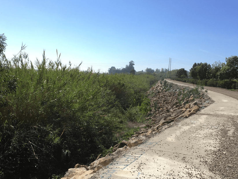
Can you imagine biking for miles with sweeping views of the Topatopa mountains far in the distance? Or walking along and smelling the coastal sage, seeing ceanothus blooms or hearing the song of a western meadowlark? The SCRLT gives us Santa Clara River knowledge. Presently the River is an unknown resource to thousands of people who live nearby because no public access is available to view and learn about its value. Out of mind, out of sight means people are unaware the river is a primary source of water to their homes, schools, farms and businesses and are indifferent about impacts occurring to its natural environment such as increased channelization and degradation to its native species. Lack of river access results in a poor grasp of its essential role in urban drainage purification, groundwater recharge, capacity to absorb greenhouse gas and to buffer sea level rise. The SCRLT is the answer to a living, breathing River needed for our health and the health of our environment.
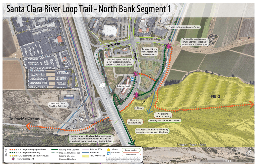
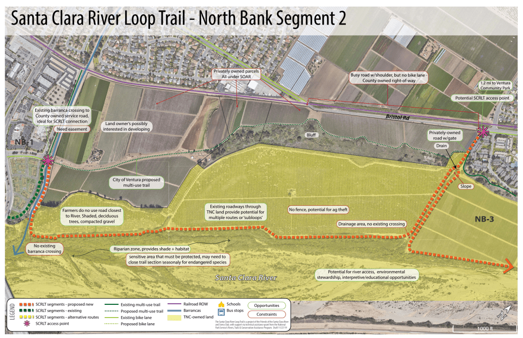
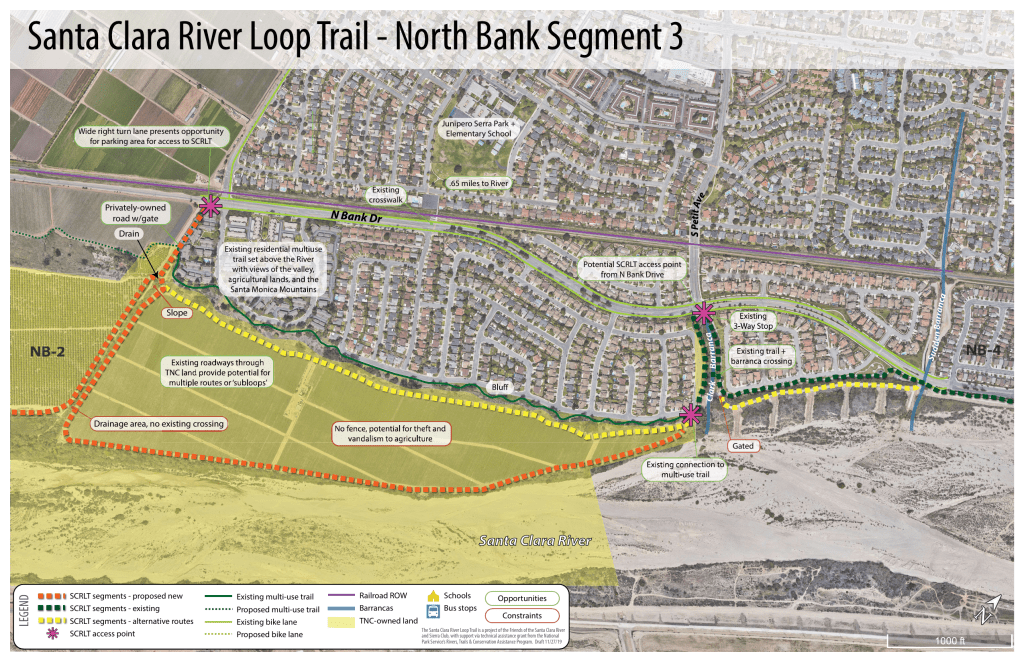
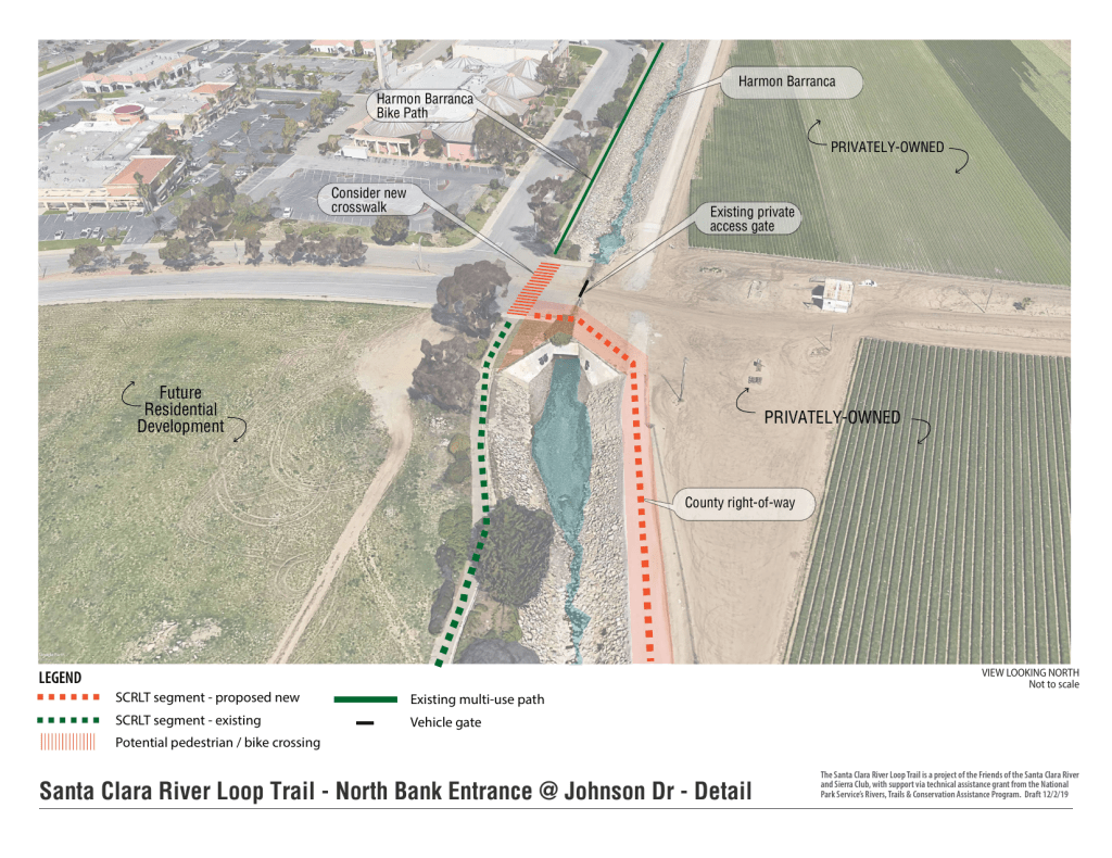
Potential Trail Map
The alignment for a Santa Clara River Loop Trail is currently under study and not final, however, possible locations are shown on the orange and yellow dotted lines.

Thoughts?
Send your input to us with the ‘contact us‘ tab on this website.
Want more information?
In September 2019, FSCR gave a presentation to the City of Ventura Bike Advisory Committee (BAC) on the Santa Clara River Loop Trail. Here is a link to a presentation of the Santa Clara River Loop Trail.
